We packed some food and fuel for a camp we hoped to establish above the couloir and set off with great optimism on 28 August. The lower part of the gully was moderate in its angle but reared up steeply the higher we climbed. I shall not risk my integrity by trying to guess the true angle of the ice. In his celebrated instructional book "Climbing Ice", the ace French climber Yvon Chouinard makes the very insightful comment that when the angle of ice begins to exceed about 55 degrees, to the climber who is trying to balance his way up on the front points of his crampons, it appears well nigh vertical! And if you are carrying a bit of a load and there are tottering towers of ice threatening to detach themselves from their moorings and come hurtling down, the precise angle does not really matter as you look at the sweep of icy white that drops away below your heels.
But we managed to cope fairly competently with the terrain, considering neither of us had any vast alpine climbing experience. As we neared the ice towers looming above us we began to traverse to the right, then climbed over some features which resembled giant white mushrooms. By afternoon we had topped out over the highest of the mushrooms and suddenly found ourselves in a trough of hard snow cradled between two crevasses and backed by an icy wall festooned with glittering icicles. We decided that this would be an appropriate location to site our next camp, and left our supplies here. We guessed - correctly as it turned out later - that the wall above provided access to the huge snow plateau of the upper mountain upon which was perched the summit.
We moved up with bag and baggage the next day. It was hard work and in places the leader opted to climb without his sack. Once secure on a better footing, he would haul the sack up via a simple pulley system we fashioned with some carabiners and slings. By the time we reached the proposed campsite, the weather was turning ugly and once again we had to pitch our tent in driving snow. Once inside the little fabric shelter we proceeded to thaw out our numb fingers before putting on a brew. Late in the evening the skies cleared and we could truly appreciate the grandeur of our surroundings.
The location was one of the most spectacular places I have ever camped on. There was a fair amount of space to move around outside the tent even though we were sandwiched between two crevasses. The view from the zippered door of the borrowed tent (Satish Patki had been kind enough to part with his prized possession on condition that if I were to damage it in any way, I was to buy him a new one!) was nothing short of gorgeous : the slope in front of us dropped away into a void and across the vast emptiness rose hundreds of peaks whose names I would not be able to recall. From the few that I could identify with a degree of certainty was Phabrang (6172m / 20250ft) its vertical northwest face and airy north ridge soaring into the sky like a giant comb to the southeast. Above the Khanjar nala to the east two beautiful and icy peaks pierced the heavens. To our right, the shelf of ice and snow was contained by the filigreed wall of the crevasse at our back, and to our left the mountain sloped away, again into an unknown abyss. Reaching this point had been a strenuous challenge and we were extremely happy that we had made it so far without incident. The conditions had been great and the towers of ice ringing the upper parts of the couloir had desisted from obliterating us. In short, it was great to be alive and boiling water for a dinner of instant noodle on our little gas stove. We had a very limited stock of the butane cylinders; this was 1986, and what climbers and trekkers in the western world took for granted was hoarded like precious metals by the minuscule community of self funded mountain climbers in India. We would sigh with envy every time we heard or read about the generously funded climbing expeditions from the Indian Mountaineering Foundation or the military who could import climbing and camping equipment rather freely - and best of all, the climbers did not have to pay for it! Ordinary mortals like us had to save our hard earned salaries, scout around for used climbing gear in the bazaars of Thamel in Kathmandu or in the hill towns of Darjeeling and Manali and use up vacation time to indulge in a little mountaineering. All climbers are definitely not created equal!
We settled down in our sleeping bags as delicate pastel hues coloured our world of ice, rock and snow. We were lulled to sleep by the smug feeling that perhaps the most difficult part of the climb was over. All we had to do was get up on to the summit plateau and trudge upwards toward the summit. We had forgotten that life tends to teach us lessons in humility at just the right moment.
We were up early with the dawn and Faruk set to work with gusto tackling the ice wall above whilst I belayed him from just outside the tent. The morning was cold and sunny, the sky was blue above Faruk, and the chunks of ice flew into the air as he hacked at the slope with his ice axe and plunged the front points of his crampons into the slope. He put in an ice screw along the way and threaded the climbing rope through the carabiner which he had clipped into the screw. With a little less distance to cover in case he fell, he kept on climbing, a little more confidently now that his security had been enhanced. This was a moment to savour : perfect weather conditions, the two of us climbing in perfect unison and in silence alone on a gigantic pile of rock and ice also known as Menthosa, eager to see what would greet us as we crested the wall.
What greeted us was the wind. It slammed into us as it swept across the wide snow plain and threatened to sweep us off our feet. We tottered away from the edge to try and get into the lee of an undulation in the snow and took stock. The summit block towered on our left hand side in a series of big snow slopes, separated from the top of the plateau by a huge crevasse. The ridge to the right seemed to offer a shorter, but perhaps steeper access to the summit area, so we began to make our way in that direction. However, we were stopped short by the gaping jaws of the crevasse. Crossing that wide gulf, with its attendant risks, did not appeal to us at all, so we retraced our steps and began to move slowly towards the left hand ridge. The snow was soft, we were sinking up to our knees and progress was extremely slow. We realised that this sort of terrain was best tackled in the freeze of predawn. By now the afternoon was well advanced, the altitude was probably around 20,000 feet, making us gasp with each step as we lunged ahead. We stopped for a short pow-wow and were unilateral in our decision to get down to our tent and make an early bid for the summit on the morrow. We were satisfied with the result of the reconnaissance, because that is what this was. We had determined that we would try and climb the mountain via its east ridge (the left hand side). In a little while we were back at the top of the ice wall down which we abseiled back to our little tent.
Determined to make an earlier start, we were out and climbing the ice wall at a quarter to six. The weather looked dubious - the clouds that had rolled in overnight refused to go away. A bitterly cold wind and spindrift stung our faces as we reached the plateau. The rising sun touched the summit with gold but we were too miserable to truly appreciate its magnificence. We hoped that the wind would pack in the snow, but it was not to be so. The snow was as soft and deep and as powdery as the day before and for hours we toiled up this, across a few well disguised crevasses and over endless humps and detours. Ragged clouds whipped across the east ridge whither we were bound. After about five hours we finally gained the ridge, through knee deep, then waist deep snow. The summit appeared to be near, but we knew that under the present conditions we would probably take another four to five hours to get there. We also had to factor in the rising altitude which had already slowed us down and would continue to do so the higher we climbed.
We stopped for a rest and considered the alternatives : if we pressed on we would be absolutely fatigued by the time we reached the summit, always assuming that there were no hidden obstacles to overcome higher up. It would be close to sunset and we would not have sufficient time nor energy to make it safely back to camp before darkness enveloped the mountain. It was a no-brainer as far as we were concerned. Yes, summits are important to climbing; but returning to the everyday world below in one piece is a far more attractive proposition. We decided to turn around.
We were exhausted by the time we reached the tent and lay around in a torpor for some time. When I could think straight again, I knew that the only way we could climb to the summit safely would be to establish another camp high on the plateau above from where we could make a quick dash to the top and retreat again. This option was not very attractive, since it meant hauling our heavy backpacks again up a very steep wall and on to the plateau, and then floundering in deep snow till we found a place to camp. Faruk had been coughing up blood for the last ten days or so and it didn't seem a healthy sign. When I quizzed him about this, he said he had a problem with his stomach, he told me not to worry, he could handle it. His bowels too seemed to have a life of their own and I knew that we should not be lingering at this altitude for longer than was absolutely necessary.
The wind died down a little after sunset and I opened the zip of the tent. The panorama in front of my eyes was magnificent. I stepped out to admire the view and take pictures. As I edged close to the crevasse which we must cross to go down, I noticed that a rather alarming crack had appeared on the snow bridge. That, for me, clinched the issue. I rushed back to the tent to deliver the glad tidings to Faruk. If that bridge collapsed, we would be trapped on our little camping spot, unable to go down the mountain. We packed up that night, waiting for the dawn to vacate what had now become a rather uneasy perch.
The mountains always seem to mock you as one prepares to vacate their sacred turf. The morning dawned brilliantly sunny, implying that we should get the hell out of there while the going was good. We were in no mood to argue: we were out of fuel, we had only a couple of snacks left, and we were exhausted after our little attempt to reach the summit.
To speed things up we rappelled down some sections and were relieved when we reached the bottom of the couloir. We could now saunter down to the Urgus pass. When we arrived at the pass, there were a whole lot of people milling around : a large team from Assam had arrived at Base Camp in our absence and were in the process of stocking up the camp on the col. We were surprised at the considerable number of High Altitude Porters they were employing, but refrained from comment. We looked around for a familiar face and sure enough there was good old Bir Singh flashing us his ingenuous smile. He and Franklyn had returned from the village the previous night and Bir Singh's instinct had told him that Faruk and I would probably be descending the mountain by now...and he had come up to help. We gladly parted with some of our loads for him to carry. Lightened in body and high in spirit, we raced down to Base Camp. One of the great things of climbing in the Himalaya is that your body is pared down to the essentials by the exertion at altitude and the aerobic workout boosts your lung power. The increase in red blood cells in the veins delivers a rich cocktail of oxygen and air when you go down to lower levels and this leads to a wonderful heady feeling of being truly alive.
A whole lot of tents had sprung up around our little kitchen shelter and we no longer enjoyed the luxury of exclusivity. Voices wafted around the camp, and snatches of conversation, loud laughter, the crunching of boots on gravel and grass. It was time to go down to Gompha.
 |
| Faruk heads out from the camp on Urgus Pass |
 |
| Taking a break as the angle steepens |
 |
| I traverse across to join Faruk at the bottom of the couloir |
 |
 |
 |
| Our Camp 2 was pitched between two crevasses |
But we managed to cope fairly competently with the terrain, considering neither of us had any vast alpine climbing experience. As we neared the ice towers looming above us we began to traverse to the right, then climbed over some features which resembled giant white mushrooms. By afternoon we had topped out over the highest of the mushrooms and suddenly found ourselves in a trough of hard snow cradled between two crevasses and backed by an icy wall festooned with glittering icicles. We decided that this would be an appropriate location to site our next camp, and left our supplies here. We guessed - correctly as it turned out later - that the wall above provided access to the huge snow plateau of the upper mountain upon which was perched the summit.
 |
 |
| We had to climb the ice wall behind the camp to gain access to the plateau |
We moved up with bag and baggage the next day. It was hard work and in places the leader opted to climb without his sack. Once secure on a better footing, he would haul the sack up via a simple pulley system we fashioned with some carabiners and slings. By the time we reached the proposed campsite, the weather was turning ugly and once again we had to pitch our tent in driving snow. Once inside the little fabric shelter we proceeded to thaw out our numb fingers before putting on a brew. Late in the evening the skies cleared and we could truly appreciate the grandeur of our surroundings.
 |
The location was one of the most spectacular places I have ever camped on. There was a fair amount of space to move around outside the tent even though we were sandwiched between two crevasses. The view from the zippered door of the borrowed tent (Satish Patki had been kind enough to part with his prized possession on condition that if I were to damage it in any way, I was to buy him a new one!) was nothing short of gorgeous : the slope in front of us dropped away into a void and across the vast emptiness rose hundreds of peaks whose names I would not be able to recall. From the few that I could identify with a degree of certainty was Phabrang (6172m / 20250ft) its vertical northwest face and airy north ridge soaring into the sky like a giant comb to the southeast. Above the Khanjar nala to the east two beautiful and icy peaks pierced the heavens. To our right, the shelf of ice and snow was contained by the filigreed wall of the crevasse at our back, and to our left the mountain sloped away, again into an unknown abyss. Reaching this point had been a strenuous challenge and we were extremely happy that we had made it so far without incident. The conditions had been great and the towers of ice ringing the upper parts of the couloir had desisted from obliterating us. In short, it was great to be alive and boiling water for a dinner of instant noodle on our little gas stove. We had a very limited stock of the butane cylinders; this was 1986, and what climbers and trekkers in the western world took for granted was hoarded like precious metals by the minuscule community of self funded mountain climbers in India. We would sigh with envy every time we heard or read about the generously funded climbing expeditions from the Indian Mountaineering Foundation or the military who could import climbing and camping equipment rather freely - and best of all, the climbers did not have to pay for it! Ordinary mortals like us had to save our hard earned salaries, scout around for used climbing gear in the bazaars of Thamel in Kathmandu or in the hill towns of Darjeeling and Manali and use up vacation time to indulge in a little mountaineering. All climbers are definitely not created equal!
 |
 |
We were up early with the dawn and Faruk set to work with gusto tackling the ice wall above whilst I belayed him from just outside the tent. The morning was cold and sunny, the sky was blue above Faruk, and the chunks of ice flew into the air as he hacked at the slope with his ice axe and plunged the front points of his crampons into the slope. He put in an ice screw along the way and threaded the climbing rope through the carabiner which he had clipped into the screw. With a little less distance to cover in case he fell, he kept on climbing, a little more confidently now that his security had been enhanced. This was a moment to savour : perfect weather conditions, the two of us climbing in perfect unison and in silence alone on a gigantic pile of rock and ice also known as Menthosa, eager to see what would greet us as we crested the wall.
 |
What greeted us was the wind. It slammed into us as it swept across the wide snow plain and threatened to sweep us off our feet. We tottered away from the edge to try and get into the lee of an undulation in the snow and took stock. The summit block towered on our left hand side in a series of big snow slopes, separated from the top of the plateau by a huge crevasse. The ridge to the right seemed to offer a shorter, but perhaps steeper access to the summit area, so we began to make our way in that direction. However, we were stopped short by the gaping jaws of the crevasse. Crossing that wide gulf, with its attendant risks, did not appeal to us at all, so we retraced our steps and began to move slowly towards the left hand ridge. The snow was soft, we were sinking up to our knees and progress was extremely slow. We realised that this sort of terrain was best tackled in the freeze of predawn. By now the afternoon was well advanced, the altitude was probably around 20,000 feet, making us gasp with each step as we lunged ahead. We stopped for a short pow-wow and were unilateral in our decision to get down to our tent and make an early bid for the summit on the morrow. We were satisfied with the result of the reconnaissance, because that is what this was. We had determined that we would try and climb the mountain via its east ridge (the left hand side). In a little while we were back at the top of the ice wall down which we abseiled back to our little tent.
 |
 |
 |
Determined to make an earlier start, we were out and climbing the ice wall at a quarter to six. The weather looked dubious - the clouds that had rolled in overnight refused to go away. A bitterly cold wind and spindrift stung our faces as we reached the plateau. The rising sun touched the summit with gold but we were too miserable to truly appreciate its magnificence. We hoped that the wind would pack in the snow, but it was not to be so. The snow was as soft and deep and as powdery as the day before and for hours we toiled up this, across a few well disguised crevasses and over endless humps and detours. Ragged clouds whipped across the east ridge whither we were bound. After about five hours we finally gained the ridge, through knee deep, then waist deep snow. The summit appeared to be near, but we knew that under the present conditions we would probably take another four to five hours to get there. We also had to factor in the rising altitude which had already slowed us down and would continue to do so the higher we climbed.
 |
| The altitude dictates a pause... |
 |
| The East Ridge appears close |
 |
 |
 |
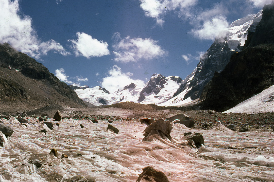
| The bergschrund at the bottom of the West Ridge as seen from the East Ridge |
 |
We were exhausted by the time we reached the tent and lay around in a torpor for some time. When I could think straight again, I knew that the only way we could climb to the summit safely would be to establish another camp high on the plateau above from where we could make a quick dash to the top and retreat again. This option was not very attractive, since it meant hauling our heavy backpacks again up a very steep wall and on to the plateau, and then floundering in deep snow till we found a place to camp. Faruk had been coughing up blood for the last ten days or so and it didn't seem a healthy sign. When I quizzed him about this, he said he had a problem with his stomach, he told me not to worry, he could handle it. His bowels too seemed to have a life of their own and I knew that we should not be lingering at this altitude for longer than was absolutely necessary.
The wind died down a little after sunset and I opened the zip of the tent. The panorama in front of my eyes was magnificent. I stepped out to admire the view and take pictures. As I edged close to the crevasse which we must cross to go down, I noticed that a rather alarming crack had appeared on the snow bridge. That, for me, clinched the issue. I rushed back to the tent to deliver the glad tidings to Faruk. If that bridge collapsed, we would be trapped on our little camping spot, unable to go down the mountain. We packed up that night, waiting for the dawn to vacate what had now become a rather uneasy perch.
 |
| This snow bridge over the deep crevasse had developed an alarming crack. |
The mountains always seem to mock you as one prepares to vacate their sacred turf. The morning dawned brilliantly sunny, implying that we should get the hell out of there while the going was good. We were in no mood to argue: we were out of fuel, we had only a couple of snacks left, and we were exhausted after our little attempt to reach the summit.
 |
| Ready....Set.... |
 |
| Go! |
 |
To speed things up we rappelled down some sections and were relieved when we reached the bottom of the couloir. We could now saunter down to the Urgus pass. When we arrived at the pass, there were a whole lot of people milling around : a large team from Assam had arrived at Base Camp in our absence and were in the process of stocking up the camp on the col. We were surprised at the considerable number of High Altitude Porters they were employing, but refrained from comment. We looked around for a familiar face and sure enough there was good old Bir Singh flashing us his ingenuous smile. He and Franklyn had returned from the village the previous night and Bir Singh's instinct had told him that Faruk and I would probably be descending the mountain by now...and he had come up to help. We gladly parted with some of our loads for him to carry. Lightened in body and high in spirit, we raced down to Base Camp. One of the great things of climbing in the Himalaya is that your body is pared down to the essentials by the exertion at altitude and the aerobic workout boosts your lung power. The increase in red blood cells in the veins delivers a rich cocktail of oxygen and air when you go down to lower levels and this leads to a wonderful heady feeling of being truly alive.
A whole lot of tents had sprung up around our little kitchen shelter and we no longer enjoyed the luxury of exclusivity. Voices wafted around the camp, and snatches of conversation, loud laughter, the crunching of boots on gravel and grass. It was time to go down to Gompha.
 |
 |
| Bir Singh carries his wife Saraswati across a torrent |
 |