Two days of idyll followed a night of sporadic rain. I dried out my shoes in the sunshine that bathed these high (approx 13,500ft) pastures at 7 am. Bir Singh had woken me up much before sunrise with a welcome cup of chai. Commander Sood and one of the Brits, "Moose", went down to Tos village to replenish their dwindling supplies of food. Ravi Chandra, the LO with the Australian expedition, told me sotto voce that the food position in the British camp was rather sad and he blamed it on Alan Hinkes, their leader, being rather "tightfisted". I listened politely to the gossip, not realizing that this was the same Alan Hinkes who was later to become a rather big name in British mountaineering circles! The Brits were attempting to climb Dharamsura ( 6446 m / 21,148 ft), also known as White Sail, first ascended in 1941 by J.O.M.Roberts. Apparently they were trying to attempt a new route up the west face of the mountain.
 |
| The summit of Dharamsura is just visible from the East Tos glacier as a little triangle beyond the white dome. |
 |
| The North East face of Dhramsura - as seen from the Bara Shigri Glacier |
Alan and another of his team members left for their higher camp, leaving behind Gary, a tall ( 6 ft 2 in ), friendly anaesthetist. Gary was primarily a rock climber and this was his first ever trip to 13,000 feet. He had taken a year off work to concentrate on climbing and had just finished a stint in the Picos mountains in Spain. He dropped in for a long chat with us and we passed a pleasant morning.
Phil, one of the two Australians, had left the camp at 4:30 am, before any of us had woken up. He planned to climb Papsura ( 6440 m ) solo because his partner Frank had lost interest after they had failed to climb the West Ridge on the mountain. Phil was planning to repeat the original route climbed in 1967 by the first ascensionists Colin Pritchard and Geoffrey Hill.
 |
| Telephoto of Papsura from the East Tos glacier |
I had a leisurely breakfast and then set off to explore the area immediately above and to the west of Base Camp. It took me two hours to reach the cirque of rocky peaks which ringed a small glacier. Again I failed to get a glimpse of Ali Ratni Tibba and could not really tell if I could see the Pass of the Animals - so named by Robert Pettigrew whose pioneering exploration of the area had found a way from the Malana glacier to the Tos valley. This little hike without carrying any load on my shoulders was exhilarating, the sun shone bright and warm and I could see behind me a long way up the East Tos glacier. I sat down on some huge boulders and ate the dates that I had stuffed into my pockets. Suddenly, there was an ominous rumbling noise that semed to originate right under me in the bowels of the earth and I felt that the slope I was on was going to collapse. I bolted like a rabbit and skated on to the relevant safety of the hard packed ice of the glacier. This was excitement enough for a rest day, so I retreated.
Bir Singh had once again produced a culinary delight with the simple ingredients of rajma, peas, potatoes and rice. After this sumptuous repast I hopped across to chat with Ravi Chandra. His tent was palatial compared to the one I shared with Bir Singh. Ravi was loquacious, recounting his other trips as LO to the peaks of Kun and Z8 in Zanskar and the bureacratic intrigue amongst the climbing clubs in Karanataka. Some time later Gary, who was getting bored all by himself, popped in as well; then all three of us came back to my tent where Bir Singh made chai. Gary invited us both for dinner on the condition that Bir Singh would make chappaties for him!
Bir Singh rolled out the chappaties on the lid of a "dekchi" (a cooking utensil), using a bottle as a rolling pin. The dinner was a big success and we all retired to our sleeping bags, full of food and good cheer. Such was social networking at Base Camps in the Himalaya before Facebook and Twitter!
I spent the next day walking up the East Tos glacier, past the icefall that descends from Dharamsura. En route I met the Australian Phil, walking back to Base Camp: his proposed solo attempt on Papsura had come to a rather abrupt end when he fell into a crevasse and just about managed to extricate himself in one piece. The experience brought home to him just how dangerous the mountains can be and so, choosing discretion as the better part of valour, he was headed down.
I could now see the upper pyramid of Papsura and a bit later Dharamsura's summit came into view far up in the distant sky. Only the tip could be seen above the bulge of its sister peak Angdu Ri. The head of the East Tos glacier was home to a number of rugged and unknown (to me) peaks, guarding access to the Bara Shigri system of glaciers behind their high ramparts. The sensation of walking alone in such a perfect wilderness was euphoric and I savoured every moment.
 |
Peak on the left bank of the East Tos glacier
|
 |
| East Tos Glacier |
I was back in camp for lunch and a welcome siesta, lulled to a comfortable slumber by bouts of rain and hail outside. I was grateful for this interlude of total relaxation; the morrow would see us climbing up to the Sara Umga pass at a little over 16,000 feet and descending the Chota Shigri glacier on the other side. I rechecked my notes on this interesting little notch in the mountains :
"...the Sara Umga La, a pass with romantic associations in the long history of Indo-Tibet trade but completely unknown to European mountaineers." Thus wrote Robert Pettigrew in the Alpine Journal in 1966. He continued - "According to A.P.F.Hamilton the pass could not be less than 16,000 feet, and it was said to be difficult. Nevertheless, it carried the ancient trade route from Ladakh, formerly known as Western Tibet, to Rampur-Bashahr in the Sutlej valley of the Punjab.
Captain Todd, who climbed in Kulu with Bruce in 1912, has described the historic events in the Beas Valley, notably the seizure of key points by the Rajput warrior-chieftains in the seventeeth century which ended the Tibetan occupation of Kulu. The excessive customs duty vigorously levied and collected by the new regime on goods passing over the Rohtang La, 13,050 feet - there is a canyon still known as Customs House - eventually closed the Rohtang and forced the trade-hungry Tibetans to seek a new pass across the Divide in an environment traditionally shunned by Indians as hostile.
Sketch map....(shows)...the trade route from the famous Bara Lacha La, 16,047 feet, to the foot of the Sara Umga La, 16,025 feet, traversing uninhabited, inhospitable and difficult terrain, finally skirted the obstructive snout of the Bara Shigri Glacier on the true left bank of the Chandra River to reach Phuti Runi (the Split Rock), the rendezvous point, in the level area still known as the Plain of the Kinnauris.
The Tibetans used 'Biangis" (big sheep) as pack animals carrying salt, borax and precious stones. They were met during October by the Kinnauris, enterprising middle-men from Bashahr in the Sutlej Valley. Encamped for a week at the foot of the Chota Shigri Glacier the barter would commence. The biangis were sheared, their wool being an important commodity for trade. The barter concluded, the Tibetans would return to Ladakh carrying the famous Lahul wheat and commodities from the plains of Punjab. In the reverse direction the Kinnauris, now with their tough little Bashahr sheep as pack animals, ascended the easy angled Chota Shigri Glacier, crossed the deep notch of the Sara Umga La, descended over steep and awkward lateral moraines of the main Tos Glacier, and continued on a good track down the true right bank of the uninhabited Tos nullah to the village of Pulga in the Parbati valley."
This graphic account of the history of the Sara Umga pass had kindled in me a strong desire to see the gap for myself. This was easier said than done...
We said farewell to Ravichandra, Gary, Frank and Phil and headed west to the crest of the moraine wall of the Tos glacier. We now had to descend onto the glacier itself and cross over to the other side before climbing up to the pass. The descent down a steep unstable slope of mud, stones and scree was hair raising. Bir Singh, in true child - of - the - mountains fashion raced down it and was soon waiting for me on the ice of the glacier. I was so spooked by then that I jettisoned both my rucksack and camera bag down the slope to be expertly fielded by my young companion. Then, with the help of my ice axe I made my way gingerly and with a great deal of trepidation down to the relatively level ground of the glacier.
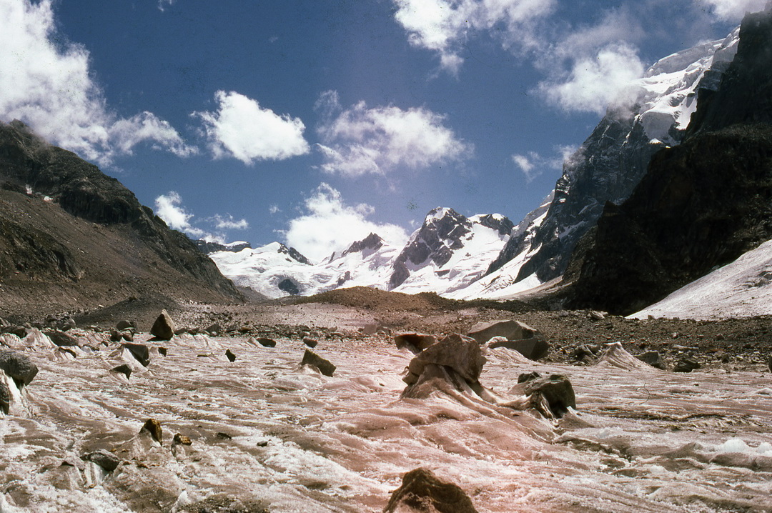
 |
| The head of the Tos glacier, glimpsed enroute to the Sara Umga La |
Once on the other side we climbed up the side of a nala down which a waterfall cascaded down and were soon at the campsite which is traditionally used before crossing the pass. The site was very impressive, with the backdrop of the monumental buttresses of red rock that flanked the Sara Umga La above. We shared some orange flavoured Amul chocolate before heading up in increasing cloud and rain. The rain soon turned to snow as we crested the pass, so we were robbed of any kind of views that this may have offered. There was a lot of snow on the pass, even so late in the season, and for the next 3 hours we weaved our way between crevasses, hopping from one safe spot to what we deemed to be another safe spot. Bir Singh did a wonderful job probing the soft snow for crevasses with the one ice axe we had and I marvelled that he was moving so comfortably in his canvas shoes. I had given him a pair of thick blue woollen socks but even so his feet must have been cold in those freezing conditions.
 |
| The lower ramparts of Sentinel peak (approx 18,000 ft.) guard one flank of the Sara Umga La. |
 |
| Bir Singh heads across the Sara Umga La |
 |
| On the Sara Umga La. |
I was relieved when the ice of the Chota Shigri glacier gave way to boulder strewn moraine. But my relief was short lived as hopping from one huge unstable boulder to another in the fading light and the rain was less than comforting. We decided to camp at around six in the evening, after a nine hour day. We were cold and wet and miserable. We pitched the tent in a most uncomfortable spot and brewed some milkless, sugarless tea because we were out of those items. Salt was an acceptable flavour so we we added that to the pan. It rained all night and we thought we might be incarcerated at this miserable camp the whole day. Braving the cold and the drizzle we packed up and moved down the glacier at 11:30 am. We were glad we did; the terrain soon flattened out and we were at the bottom of the Chota Shigri! It occured to me that those Bushahri sheep must have been really hardy little critters to be able to cross the Sara Umga La!
 |
| The gorge of the Chota Shigri can be seen across the river. |
There was a movement far across the Chandra river on the other side of the valley : it was the Kaza-Kullu bus. We saw it stop at the collection of tin sheds known as Chota Dhara before moving downstream towards Chatroo, the same stop we were headed for. In spite of the rain the walk was pleasant enough as it traversed some beautiful meadows blooming with wildflowers and criss crossed with gurgling brooks and filled with the song of wagtails (Bir Singh called them "rejicha" in Lahuli) hopping from one stream to the next. When I gushed about the flowers to Bir Singh, he snorted..."Come to the Miyar Nala, saab", he said, "and I will show you meadows teeming with wildflowers like you've never seen". Little did I know, but this little statement of his was to form the seed from which would spring my next mountain adventure less than a year later - a trip to climb the peak of Menthosa in the Miyar Valley, just a day's hike up from Bir Singh's village of Urgus!
 |
| Bridge over the Chandra river at Chatroo |


Loved it.
ReplyDeleteBeautifully written.
ReplyDeleteGorgeous photos, and very well written. I am sharing this, with your permission
ReplyDeleteThank you Ritu....go ahead and share this...that is the whole purpose of this blog, to share the incredible experiences that the Himalaya have given me over the decades!
ReplyDeletehello sir i am planning SARA UMGA in few days can u tell me that is their any chances of being lost in the trek or is the route clear and ease and what kind of material should we carry because we are not hiring any porter and guide its only friends tour so pls guide us before 22nd august
ReplyDeleteyour trip report and photographs have made me start thinking of doing it myself. Can you please provide me the contact number of your guide Mr. Bir singh. I would not dream of a high altitude trek without proper experienced guidance. My mail id is sarmilade2008@gmail.com. Would be very grateful for your help. Thanks.
ReplyDelete